Basic Information about Manipur
| Particulars | Data | Representative Picture |
|---|---|---|
| State Emblem | Kangla Shaa | 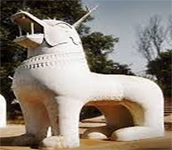 |
| State Bird | Nongyeen | 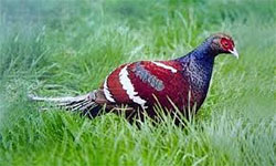 |
| State Animal | Sangai | 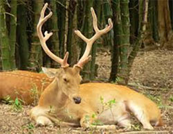 |
| State Flower | Siroy Lily | 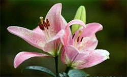 |
| State Game | Manipuri Polo | 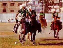 |
| Area | 22,327 sq.km |
| Population | 2,570,390 (2011 census) |
| State Language | Manipuri |
| Density of Population( per km2) | 115/km2 (2011 Census) |
| Literacy Rate | 79.21% (2011 Census) |
| Altitude | 790 mtrs above MSL (Imphal) |
| Latitude | 23.830N to 25.680N |
| Longitude | 93.030E to 94.780E |
| Rainfall | 1467.5mm (Avg.) |
| Rainy Season | May to October |
| Schedule Tribes | 33 (Recognized by Government) |
| Assembly Constituencies | 60 (40 General, 19 ST, 1 SC) |
| Parliamentary Constituencies | 2:( Inner – 1 & Outer – 1) |
| National Highways | 339 – Indo-Myanmar road53 – New Cachar Road150 – Jessami-Tipaimukh Road |
History of Manipur
Manipur had been known throughout the ages as Meitrabak, Kangleipak or Meeteileipak as well as by more than twenty other names. Sanamahi Laikan wrote that Manipur’s new nomenclature was adopted in the eighteenth century during the reign of Meidingu Pamheiba. According to Sakok Lamlen, the area had different names according to the era. During the Hayachak period it was known as Mayai Koiren poirei namthak saronpung or Tilli Koktong Ahanba, then in the Khunungchak period as Meera Pongthoklam. Thereafter during the Langbachak era, it became Tilli Koktong Leikoiren and finally Muwapalli in the Konnachak epoch.
During the latter part of its history, Manipur and its people were known by different names to their neighbours. The Shans or Pongs called the area CASSAY, the Burmese KATHE, and the Assamese MEKLEE. In the first treaty between the British East India Company and Meidingu Chingthangkhomba (Bhagyachandra) signed in 1762, the kingdom was recorded as MECKLEY. Bhagyachandra and his successors issued coins engraved with the title of Manipureshwar, or lord of MANIPUR and the name Meckley was discarded. Later on, the Sanskritisation work, Dharani Samhita (1825–34) popularized the legends of the derivation of Manipur’s name.
The documented history of Manipur begins with the reign of the Meetei King of Ningthouja clan NONGDA LAIREN PAKHANGBA (dragon king/god) (r. 33–154 AD), who unified the seven clans of Meetei society. KANGBA was the first king about whom the chronicles provide details. He was born in the Koubru hills of the northwest Manipur Valley. He was the son of Tangja Lila Pakhangba. Meeteileipak (Manipur) was known as Tilli Koktong Leikoiren during the Kangba Period.
The next confirmed king was MALIYA (or MARIYA) PHAMBALCHA. According to the Kangbalon, KOIKOI, the first son of Kangba, ascended the throne and assumed the regnal title of Mariya Phambalcha. Many scholars fix Maliya Phambalcha’s era to 1379 BC and the time he established the Meitei Calendar.
According to the Thiren Layat, there were nineteen rulers up until the joint reign of Nongdanhan and Taohuireng. The ancient Numit Kappa text compares the two brothers as if they were two sons. The hymn of Numit Kappa used in the rite known as Chupsaba and sometimes sung as a ballad, narrates these events.
Introduction of the Vaishnavism school of Hinduism brought about changes in the history of the state. Manipur’s early history is set forth in the CHEITHARON KUMBABA, a chronicle of royal events which is believed to record events from the foundation of the ruling dynasty. Since ancient times, the Meitei people have lived in the valleys of Manipur alongside the Nagas, and the Kukis in the hills. Meitei Pangal (Muslim) community got settled in the valleys during the reign of Meidingu Khagemba in the year 1606 and since then, they have lived along with the Meetei community as is seen now.
Manipur then became a princely state under British rule in 1891; the LAST of the independent states to be incorporated into British India. The British government selected MEIDINGNGU CHURACHAND SINGH (1891–1941), minor son of Chaobiyaima as the king of Meitrabak. A new Kangla Palace was constructed at Wangkhei and Kangla was kept under British occupation. During British colonial rule, Kangla was known as Manipur Fort and a battalion of Assam Rifles was stationed there. During the Second World War, Manipur was the scene of battles between Japanese and Allied forces. The Japanese were beaten back before the Allies could enter Imphal. This proved to be one of the turning points of the War. The British left Manipur in 1947 following Indian independence.
After the war, the Manipur Constitution Act, 1947, established a democratic form of government with the Maharaja as the Executive Head and an elected legislature. In 1949, MAHARAJA BUDHACHANDRA was summoned to Shillong, capital of the Indian province of Meghalaya where he signed a TREATY of ACCESSION merging the KINGDOM into India. Thereafter the legislative assembly was dissolved and Manipur became part of the Republic of India in OCTOBER, 1949. It was made a union territory in 1956 and a full-fledged state in 1972. Mohammed Alimuddin became the first Chief Minister of the State of Manipur in 1972.
.[/spoiler]
Present ManipurMeidingu Pamheiba (1708-1747) (popularly known as Garibniwaz – a name given by Muslim immigrants for his kindness to the poor) was a major religious reformer and under his royal patronage Shri Chaitanya’s school of Gaudiya Vaishnavism gradually spread across Meitrabak. The Cheitharol Kumbaba records that in October 1717, Graibniwaz was initiated into Vaishnavism by Guru Gopal Das. Later in life he also took instruction from the Ramanandi Sampradaya school of thought. Sanamahi Laikan recorded the events surrounding Sanskritisation which paved the way for “Meiteileipak” or “Kangleibak” to become “Manipur”. Many other Meiteileipak place names in the Manipuri language (Meiteilon) were also changed to Sanskrit. The Hinduised word “gotra” was introduced for the Seven Yek/Salais of Meiteis. Between 1717 and 1737, the Sanskrit epic parvas the Mahabharata and Ramayana were translated into Meiteilon while many other Sanskrit Parvas were written by Angom Gopi (1710–1780), the renowned scholar and poet at the court of Meidingu Pamheiba. The king and all the Meiteis were converted as Kshatriya by relating to Mahabharata’s Manipur. But the fact is Vaishnavism practiced by Meiteis in Manipur consequently became a peculiarly Manipuri Vaishnvism in form, adopting aspects of olden culture and modified by it. Before the advent of Hinduism following the event of oath taking known as Nongkhrang Iruppa in 1724 A.D during the reign of King Pamheiba, the Meiteis professed their traditional Sanamahi religion and even after this oath taking event by several hundreds of Meiteis under the threat of ostracization by holding the “Nongkhrang” plant, those who disapproved the new religion defied the harsh prerogative of the King, social ostracization at the instances of émigré priests and professed their conventional religion. As seen today, every Meitei household worships Lord Sanamahi with whom the real Meitei spirit had been merged and they follow the ceremonies of Hinduism and outward forms without lending an emotional attachment whatsoever. It can therefore be observed from the above account that the traditional religion of the Meiteis could not be eroded in-spite of the King repressive measure by adopt Hinduism. So the King and his few wise men synthesized the new religion with the traditional religion. The concept of Hinduism has a different form in Manipur. It is further supported by that fact that, in every household of the valley of Manipur particularly among the Meitei, a small area is reserved in the room of the household elders for the traditional god “Sanamahi” irrespective of their religion.
The present boundary of Manipur with an area of 22,327 sq. km. more or less remained fixed since the controversial transfer of Kabaw Valley to Burma (now Myanmar) in 1834. But in olden days it was much bigger than its present size with fluctuations at various stages. R.B. PEMBERTON observed as, “The territories of Muneepoor have fluctuated at various times with the fortunes of their princes, frequently extending for three or four days’ journey east beyond the Ningthee or Khyendwen river, and west to the plains of Cachar” (Pemberton 1966). Sir JAMES JOHNSTONE also observed that “The territories of Manipur varied according to the mettle of its rulers. Sometimes they held a considerable territory east of the Chindwin River in subjection, at other times only the Kubo Valley, a strip of territory inhabited not by Burmese, but by Shans” (Johnstone 1971). At one time the eastern boundary of Manipur extended up to the peripheral limits of China and Burma, while the south-sea remained as the southern boundary and Hiramba’s Kingdom (Dimapur) as the northern boundary (Singh Mutum Jhulon cited in AMCTA 2001). This account is also supported by Alexander Mackenzie’s in his book, The North-East Frontier of India. Towards the west the boundary of Manipur, although not properly defined, as referred in the treaty of 1763, was extended upto the Brahmaputra Valley. In 1835 indeed the forest between the Doyeng and the Dhunsiri was declared to be the boundary between Manipur and Assam (cited in AMCTA ibid). SUPPORTING THE ABOVE ACCOUNT Sir James Johnstone MENTIONED IN HIS BOOK “Manipur and Naga Hills” THAT RAJA GAMBHIR SINGH REDUCED SEVERAL VILLAGES TO SUBMISSION, INCLUDING THE LARGEST OF ALL, KOHIMA, AT WHICH PLACE HE STOOD UPON A STONE AND HAD HIS FOOT PRINTS SCULPTURED ON IT, IN TOKEN OF CONQUEST.
In the post-independence period, the representatives of the hill tribes were appointed as Ministers of the State which had never occurred in the history of Manipur. In the election of 1948, 18 seats were reserved for the hills but not on the basis of tribes, the remaining seats were for the valley including Mohammedans. Democracy had provided the opportunity for participation in the governance of the State either as Ministers or 108 members of the Assembly. Every community was represented except the Mao as there was no election due to political agitation. The election of 1948 was the endorsement of the State by the people of Manipur in a democratic way. There were 8 Naga MLAs – 5 Tangkhuls, 2 Zeliangrongs and one Monshang, the other 9 were Kuki-Chins including Kom and Paite. In this short-lived experiment in constitutional monarchy, the tribal people accepted the primal position of the Maharaja as the head of the kingdom and leadership of the Meiteis in the democratic set-up as the Chief Minister was a prince appointed by the Maharaja. The hill people accepted the Maharaja as the symbol of unity of the kingdom. This symbol was destroyed when the State was merged with the Dominion of India in October 1949. The merger of Manipur with India was made between the then Governor General of India and his Highness, the Maharajah of Manipur. The Merger destroyed both autonomy and democracy of Manipur and brought a bureaucratic Central rule under a Chief Commissioner. This was, in practice, the continuance of the colonial rule, a mere replacement of the white men by the brown sahibs of the Government of India. This was a most unfortunate political development in the modern history of Manipur which was as disastrous as the British conquest of Manipur of 1891 in its consequences. Had the Government of India permitted the continuation of the working of the Manipur State Constitution within Indian Union, the people would not have felt the change from the Maharaja to the Chief Commissioner.
An agreement was made as Manipur was one of the most uncertain native states due to some delicate issues and problems. The agreement stated that in the interest of both the state of Manipur and the Indian governance, Manipur would be under the administration and jurisdiction of the Dominion Government of India. This agreement made between the newly formed Congress-led government of India and Maharajah Bodhchandra Singh came into effect from 15th October 1949.
The merger of Manipur with India vested all the jurisdiction of the state on the central government. One of the most important chapters in Manipur history, it was made to bring peace and improvement for Manipur. However it also stated that the Maharajah would continue to enjoy the same personal rights and privileges he had till date. It also meant that the Maharajah of Manipur, his family and successors would continue to have the authority and power they enjoyed before the merger. In spite of the signing of the agreement, it was decided that the Maharajah of Manipur would continue to have his titles, customs, religious practices, rites, dignities, institutions and ceremonies as it used to be.
The transfer of power through the historic merger of Manipur, however, was made in lieu of 30 million rupees annually that the Indian Government agreed to pay to the Maharajah and his family. This sum was ensured to cover all expenses of the Maharajah and his family, during his lifetime. The government of India also assured the private property of the Maharajah to be only his.
Once an independent kingdom, MANIPUR, declared free once more in 1947, however, became a part of the Indian Dominion following signing of the above Merger Agreement.
In the year 1972, it became the State we see and know of today – a live example of once a GREAT and an INDEPENDENT KINGDOM, abundant with great WARRIORS and KINGS, INTELLECTS, CUSTOMS, SOCIAL STRATA and RELIGION, turning into a COMPLETELY DEPENDANT and a CONFUSED Indian State!
Statistics”]1. LOCATION, AREA & MAP
Location:
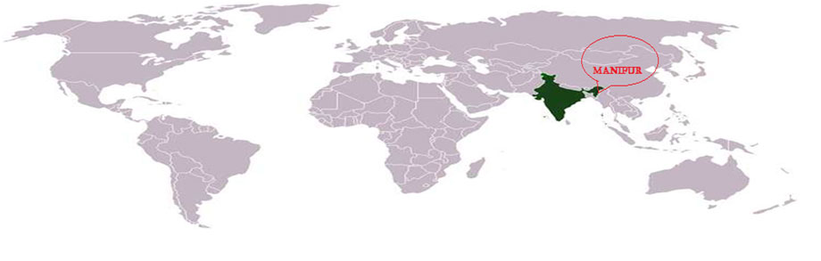
Manipur is one of the 8 States which lie in the north eastern region of the country of INDIA. The other 7 Indian States in the region are Assam, Arunachal Pradesh, Meghalaya, Mizoram, Nagaland, Sikkim and Tripura. Geographically, the state of Manipur lies at a latitude of 23°83’N – 25°68’N and a longitude of 93°03’E – 94°78’E.
The State is situated in the extreme northeastern region and its boundaries are surrounded by 3 Indian states, namely, NAGALAND (in the north), MIZORAM (in the south), ASSAM (in the west) and by the borders of the country Myanmar or Burma in the east as well as in the south.
Area:
The total area covered by the State is 22,327 sq.km (8,621 sq mi).
The capital city of the State, Imphal, lies in an oval-shaped valley of approximately 2,000 sq.km (700 sq mi). The valley is surrounded by 9 hill ranges in circles creating a hill and trough geography and is at an elevation of 790 metres above the sea level. These mountain ranges prevent the cold winds from the north from reaching the valley and also bar cyclonic storms originating from the Bay of Bengal, thus creating a usually calm and a moderate climatic environment in the state.
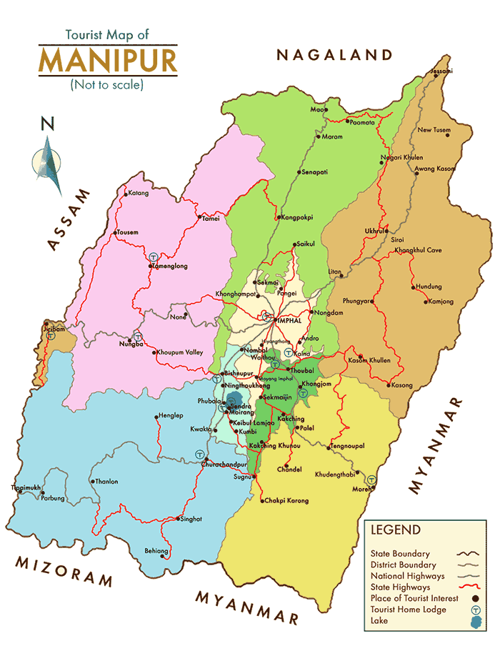
Map:
2. POPULATION
As per Census 2011, the total population of Manipur at 0.00 hours of 1st March 2011 is 2,570,390 .Of this, the rural population is 1,736,236 and the urban population 834,154. In absolute numbers, out of the total increase of 403,602 added in the last decade, the contribution of rural is 145,416 and urban area is 258,186.
In 2001, total population was 2,293,896 in which males were 1,161,952 while females were 1,131,944.
The total population growth in this decade was 12.05% while in previous decade it was 30.02%. The population of Manipur forms a mere 0.21% of India in 2011. In 2001, the figure was 0.22%.
Population density of Manipur is 115 per sq km which is lower than national average 382 per sq km. In 2001, density of Manipur was 103 per sq km, while national average in 2001 was 324 per sq km.
The Sex Ratio in the state which was 978 in 2001 has increased by 14 points to 992 in 2011.
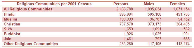
3. COMMUNITY COMPOSITION
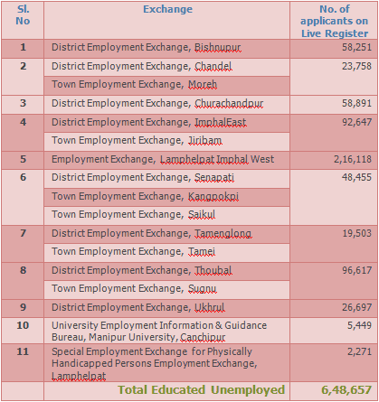
4. UNEMPLOYMENT STATISTICS
A high rate of unemployment exists in Manipur, particularly among the educated youth. According to the Live Register of Employment Exchange, the total number of educated job-seekers were recorded as 6,48,657 as on June 2009 (no new data available).
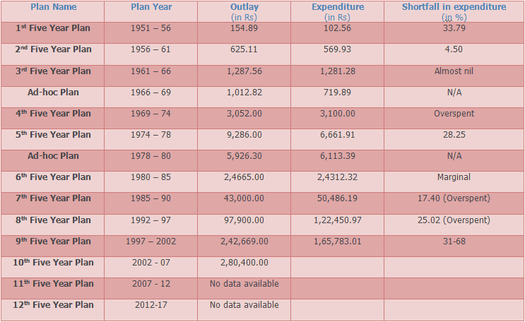
5 YEAR PLAN
Central Five Year Plan Outlay & Expenditure in Manipur (Rs. in lakhs) since the inception of the Programme
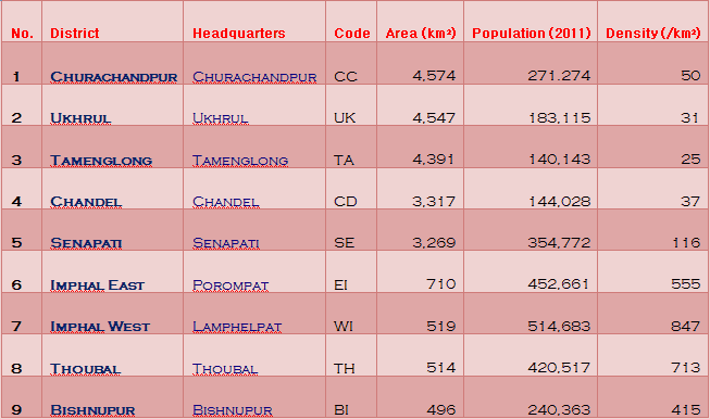
DistrictsThere are in total 9 Districts in Manipur. Below is a list of the Districts arranged in order of area size.
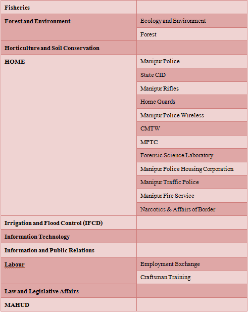
Government & DepartmentsThere are in total 9 Districts in Manipur. Below is a list of the Districts arranged in order of area size.
– GOVERNMENT
| MANIPUR LEGISLATIVE ASSEMBLY | AUTONOMOUS DISTRICT COUNCIL |
|---|---|
| The first Manipur State Assembly was elected on adult franchise in July 1948 – the first of its kind in India.“The representative returnable from General, Hill and Mohammedan constituencies were in the ratios of 30:18:3 respectively with an additional two seats for the representatives of Educational and Commercial interests”. The whole valley of Manipur was divided into 29 constituencies. Three of them were plural constituencies. That is each voter had two votes, one for the Mohammedans and the other for the non-Mohammedans. “The special constituencies from which one Muslim and one Hindu were returned were Lilong, Mayang Imphal and Yairipok”. The Jiribam (Rajbari) (Hill area) was allotted a general seat. The whole hill area of Manipur was divided into 18 single member constituencies. The hill man residing in the valley demanded that one seat should be allotted to them in one of the valley constituencies. Accordingly, “Moirang constituency was made a special constituency from which one Hill representative and one valley representative were elected”. Therefore, the Manipur Legislative Assembly consisted of 53 seats. The State Assembly was, however, dissolved after Manipur was merged with the Dominion Government of India on 15th of October 1949. Manipur became a Part C State and the State continued to be administered by the President through a Chief Commissioner or a Lieutenant Governor who acted as his agent.There was an Advisory Council appointed by the President in consultation with the Chief Commissioner. The Council met once in three months presided over by the Chief Commissioner. The Council was an advisory body and as such its advice was not necessarily binding on the Chief Commissioner. On November 1, 1956 Manipur ceased to be a Part C State. Manipur became a Union Territory under the Union Territorial Council Act, 1956. The Territorial Council consisting of 30 elected Members and 2 nominated Members was constituted on 16.8.1957. The Territorial Council was later converted into the Territorial Legislative Assembly in June 1963. The Territorial Legislative Assembly consisting of 30 elected Members and 2 nominated Members started to function from 23.7.1963.With the enactment of the North-Eastern Areas (Re-organization) Act, 1971 by the Indian Parliament Manipur was conferred full statehood on 21st January 1972 with a 60 Member Legislative Assembly | – Churachandpur ADC- Chandel ADC- Senapati ADC- Sadar Hills ADC- Tamenglong ADC- Ukhrul ADC |
– DEPARTMENTS
Tourist GuideManipur being a favourable tourist destination in the North Eastern part of India, all tourists visiting the State should get acquainted and informed of of the various requirements and possibilities that one can do/experience in the State during their visit. Following are a brief outline of how you can safely visit, stay, explore and enjoy yourself in the state of Manipur:
1. Equip yourself with
| Specific Permission | Entry Formalities | Vaccination & Health Precautions | Tourist Information Centres & Helpline Nos. |
|---|---|---|---|
| Equipped with a valid Visa (for foreigners), travelling to Manipur will not require any other additional permit for your visit. Possibilities may be that you may need to register yourself with the Foreigners Registration Officer (FRO) of the State or with the Superintendent of Police (CID/SB), Manipur, upon your arrival and departure. However, you may be required to acquire Restricted Area Permit (RAP) while entering other neighbouring North Eastern states like Arunachal Pradesh, Mizoram and Nagaland in addition to other valid travel documents that you may accompany during your journey. | All tourists from outside India intending to visit the State can visit Manipur subject to the following conditions:
1. Citizens of Afghanistan, China and Pakistan and foreign nationals having their origin in these countries would continue to require prior approval of the Ministry of Home Affairs before their visit to the State of Manipur. 2. Citizens of Myanmar visiting the State of Manipur beyond 16 Kms. from the IndoMyanmar border would continue to require prior approval of the Ministry of Home Affairs before visiting the State. 3. All foreigners visiting Manipur will register themselves with the Superintendent of Police (CID/SB), Manipur, the offices of which are located in the capital city Imphal, and with the Foreigners Registration Officer (FRO) of the State within 24 hours of their arrival. Check points are located at various entry points, i.e. Imphal Airport, Mao, Moreh and Jiribam. 4. Foreign Missionaries visiting the State may be given ‘Missionary Visa’ as per the provisions of Chapter 7 of the Visa Manual. |
Although no specific vaccination may be required, it is recommended, particularly if you plan a long trip or intend visiting remote areas of the state. Some common illness you need to take special care of are: Typhoid (monovalent), Polio, Tetanus, Hepatitis A, Hepatitis B, Rabies, Malaria, Diphtheria, Whooping Cough, Mumps, Measles, Rubella, Diarrhoea, Amoebic dysentery and Dengue fever. According to your plans and schedule of visit, you may consult yourself with special health departments prior on your arrival. | Tourist Information Centres:
1. AT IMPHAL 2. AT GUWAHATI 3. AT KOLKATA 4. AT DELHI (i) Manipur Information Centre C7 (ii) Manipur Bhawan (Old), (iii) Bir Tikendrajit Bhawan (New), Emergency (Tourist) Helpline Nos.: |
2. Safety & Comfort
| General Safety | Safe Hours | Weather Suitability | Road & Travel Conditions |
|---|---|---|---|
| Many people still resent the Indian government and there are some misunderstandings amongst some communities in the state and as such you are advised to take a brief stock of the time and place of your scheduled outing activities during your stay in the state.Various competing militias are present in the state although dacoity, local hooliganism, beggary, pick-pocketing etc as usually seen in other states of India are generally absent.Capital city Imphal is generally safe, but in case if you are visiting other (remote) areas of the state, good prior information about the place(s) you intend to visit should become helpful and advantageous. NB: The word ‘disturbed’ wherever found tagged or written, it is advised that such areas are best avoided. | Imphal: 5 am – 8 pm (safe for any outing activities like city sightseeing, shopping, marketing, et el) Other Areas: 6 am – 4/5 pm (you may however limit your venturesome hours to 3 pm for the best safety). |
October-March: Best time to visit Manipur. This winter-spring period is usually pleasant and full of sunshine – scantily rains during this period. You can experience clear skies, greeneries and soothing air during this period of the year.
April-June: Warm/Hot and humid – not suitable for outings and adventurisms. Temperature may range from 25 to 38 degrees during this period. June (end)-September – Monsoon season, mostly rainy. For those who love rain, this period suits best. |
Although the means of communication and travel in and around the state may be abundant and favourable, the condition of roads is usually not to the standard, except for some parts of the capital city Imphal.No major traffic jam issues, except in some parts of the Imphal city during office hours.The state has no local train or tram facility. Both hill and plain areas may usually be wet and slippery during rains – in case of heavy rains, most city areas may usually get flooded – whilst during winter and spring, most places have clear, green and airy look – a rare sight and feel you can enjoy during your very stay in the state! |
3. How to, Where to & What to
| Reach By | Stay At | To See | To Dare | To Eat & Drink | To Buy | To Participate | To Shop At |
|---|---|---|---|---|---|---|---|
| AIR: Direct from Delhi, Bangalore, Mumbai Kolkota and Guwahati and via connections from all other states of India.
TRAIN:No passenger train direct to Manipur but can be reached upto Guwahati or Dimapur in Nagaland (nearest rail head) and proceed thereon via roadways. ROAD:– Direct by Night-Super Buses and private vehicles from Guwahati via NH39 Highway. Usually takes upto 18-20 hours.- Direct by Night-Super Buses, Winger Taxis, Sumo vehicles etc from Dimapur via NH39 Highway. Usually takes 8-10 hours.- Direct by Night-Super Buses from Guwahati / Silchar / Shillong via NH53 Highway. Usually takes upto 28-30 hours.- Direct by Night-Super Buses, Winger Taxis, Sumo vehicles etc via Moreh Town in the east through NH39 route. |
State Guest House – Sanjenthong, Imphal Hotel Imphal – North A.O.C., Imphal The Classic Hotel – North A.O.C, Imphal Hotel Nirmala – M.G Avenue, Imphal Hotel White Palace – M.G Avenue, Imphal Hotel New Airlines – M.G Avenue, Imphal Hotel Prince – Thangal Bazar, Imphal Hotel Pintu – North AOC., Imphal Hotel Tampha – North AOC., Imphal Hotel Avenue – M.G Avenue, Imphal Youth Hostel – Khuman Lampak State Youth Centre – YAS. Govt. of manipur Khuman Lampak, Imphal Hotel Anand Continental – Thangal Bazar, Imphal Hotel Kristina – Pologround Road , Paona Bazar Mass Hotel – Assembly Road, Imphal Hotel Deesh Delux – Thangal Bazar ,Imphal Hotel Yaiphaba – MG Avenue, Imphal |
Kangla Fort – Imphal Loktak Lake – Bishenpur Langthabal Monuments – Imphal Keibul Lamjao National Park – Bishenpur Khongjom War Memorial – Thoubal Manipur State Museum – Imphal Manipur Zoological Garden – Imphal Phubala Lake – Bishenpur Shaheed Minar – Imphal Shri Govindjee Temple – Imphal Sendra Resort – Bishenpur Ebudhou Thangjing Temple – Bishenpur Waithou Lake –War Cemetery – Imphal Chorus Repertory Theater – Imphal Kaina Ching – Thoubal Khonghampat Orchidarium – Imphal Tharon Cave – Nupilal Memorial Complex – Imphal Singda Dam – RKCS Art Gallery – Imphal The ISKCON Temple – Imphal Samban Lei Sekpil – Imphal Ima Keithel – Imphal |
TrekkingCycle TourClimbingBoating / RowingResearch activities | Eromba – Vegetables and/or potatoes boiled with quite a good amount of red chillies or Umorok with ngari (fermented fish), dry fish and mashed together.
Umorok – literally ‘tree chilli’. Can be garnished with local vegetable kinds to have a spicy and a hot recipe. Singju – Singju is a kind of salad prepared with finely chopped local vegetables. Chamthong or Kangshoi – It is a stew preparation of any seasonal vegetables with ngari (dry fermented local fish) Morok metpa –It is a coarse-paste prepared with green or dry red chilies with/without ngari. Ok-Soibum – Local pork curry with bamboo shoots or mustard leaves with U-morok. Kanghou-Bora – A typical Manipuri style evening snacks found nowhere else in the country. Mostly fried and spicy and available in different variety. Tan-Saag – A typical Manipuri style roti/puri available only in early morning hours. Tastes completely different from rotis/puris available elsewhere in the country. Have it with a white/red tea! Utti Thongba – A dish prepared from muttor/dried peanuts in a uniquely different Manipuri style – again not available elsewhere in the country. Sekmai/Andro Yu – For those who drink, a local and traditional spirit which can give you finest of kicks. |
Cane and Bamboo Crafts
Kauna – Mats, and cushions made out of a kind of reed found in wetlands and marshes |
Participate and enjoy the festivals below if your visit falls during the time of celebration:
Yaoshang (Holi) – Traditional festival of colour – usually falls in March Cheiraoba – Manipuri New Year – March/April Lai Haraoba – Traditional merry-making festival for indigenous Gods – usually from April to July Kang Chingba – Traditional rath yatra festival – July/August Panthoibi Latpa/Durga Puja – Worship of Goddess Panthoibi/Durga – September/October Diwali – Festival of lights – November Ningol Chakkouba – Festival of eternal love and connection between brothers and (married) sisters marked by a grand feast at her paternal house. – November Kut Festival – Harvesting Festival of Kuki-Chin-Mizo community -November Gaan-Ngai – Post Harvest/Winter Festival – celebrated by Zeliangrong community – December/January |
Ima Market – Imphal Moreh Market – Imphal Paona Market – Imphal Thangal Market – Imphal Singjamei Market – Imphal Thoubal Market – Thoubal Moirang Market – Bishenpur |
Places of Visit
| Place Name | Brief Description | Distance from Imphal | Picture |
|---|---|---|---|
| Shaheed Minar | The indomitable spirit of the patriotic Meitei and tribal martyrs, who sacrificed their lives while fighting the British in 1891, is commemorated by this tall Minar at Bir Tikendrajit Park in the heart of Imphal city. | 0-1 km | 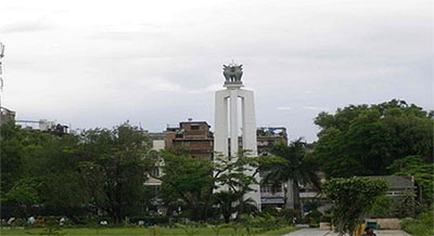 |
| Khwairamband Bazar/Ima Keithel (Market) | A unique all women’s market, having 3,000 or more “Imas” or mothers who run the stalls. It is splited into two sections on either side of a road. Vegetables, fruits, fishes and household groceries are sold on one side and exquisite handlooms and household tools on the other. | 0-1 km | 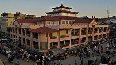 |
| Kangla (Fort) | The centre of Manipur’s power till 1891, the historical embodiment of Manipur Rulers and the people of Manipur, Kangla have a significant place in the heart and mind of the people of Manipur Govindajee temple, outer and inner moat and other relics are perfect reflections of the rich art and culture of Manipur and her civilization. | 0 km | 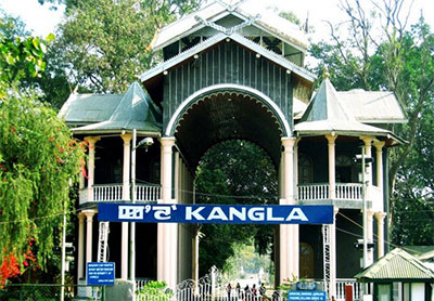 |
| Shree Shree Govindajee Temple | A historic Vaishnavite centre, adjoining Manipur’s former Maharajas’ Royal Palace, the Govindajee temple is one of the most attractive sights for the tourists. Twin domes, a paved courtyard, and a large raised congregation hall form a perfect backdrop for priests who descend the steps, to accept offerings from devotees in the courtyard. The shrines of Lord Krishna and Balaram and Jagannath flank the two sides of the presiding deity. Early hours Prayer (Aarti) is a must for devoted followers, exudingspiritual fervour and ecstasy. | 0-1 km | 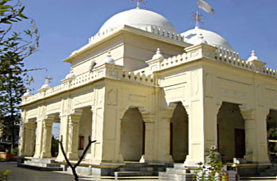 |
| Manipur State Museum | This interesting Museum near the Polo Ground has a fairly good collection and display of Manipur’s tribal heritage and a collection of portraits of Manipur’s former rulers. Particularly interesting items are costumes, arms & ammunitions, relics and historical documents. | 0-1 km |  |
| War Cemetery | Commemorating the memories of the British and Indian soldiers who died during the World War II, these War Cemeteries are managed by the Commonwealth War Graves Commission. Serene are well maintained, the War Cemetery carries little stone markers and bronze plaques recording the sacrifice of those gallant soldiers. | 0-1 km | 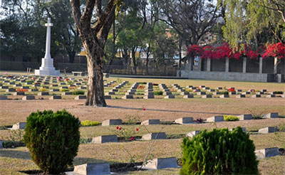 |
| Manipur Zoological Garden | Manipur Zoological Garden at Iroisemba is only 6 kms. on the Imphal-Kangchup Road at the foot of the pine growing hillocks . Here apart from various endangered species, tourists can have an opportunity to see the graceful brow antlered deer (Sangai), one of the rarest & endangered species in the world, in sylvan surroundings. | 6 kms | 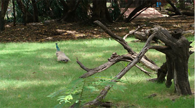 |
| Loukoi Pat | This tiny lake located near the Tiddim Road on N.H. 150 at Bishnupur is a retreat for visitors from within and outside the state. Boating facilities and the scenic beauty of the place is able to mesmerise the visitors. | 30 kms | 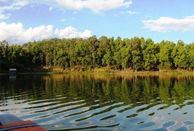 |
| Khonghampat Orchidarium | 10 kms. from Imphal on National Highway No. 39 is the Central Orchidarium which covers 200 acres and houses over 110 rare varieties of orchids, which include dozens of endemic species. The peak blooming season is March-Apr | 10 kms | 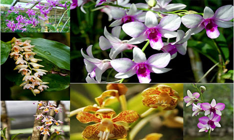 |
| Loktak Lake | 48 Kms. from Imphal, is the largest fresh water lake in the North East Region. From the Tourist Bunglow set atop Sendra Island, visitors get a bird’s eye view of life on the Lake small islands that are actually floating weeds on which the Lake-dwellers live in the backdrop of the shimmering blue water of the Lake, labyrinthine boat routes and colourful water plants. The Sendra Tourist Home with an attached Cafeteria is an ideal tourist spot. Boating and other water sports are organised here in Takmu Water Sports Complex. | 48 kms | 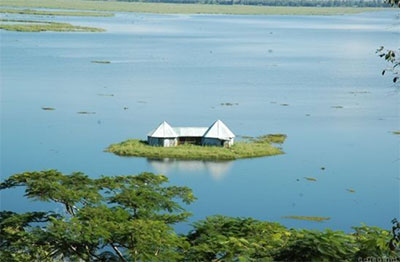 |
| Red Hill (Lokpaching) | Red Hill is a hillock about 16 kms. from Imphal on Tiddim Road (NH – 150). It is a thrilling spot where the British and the Japanese fought a fierce battle during World War II. War Veterans had constructed “India Peace Memorial” a monument in memory of Japanese soldiers who died in the battle. It is a place of pilgrimage for Japanese tourists. | 16 kms | 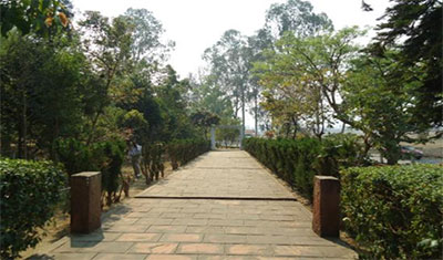 |
| Sadu Chiru Waterfall | About 20 Kms. from Imphal beside the Tiddim Road (NH150) is a picturesque site famous for its perennial Water Fall in a scenic foot hill. There are three waterfall spots. This is a newly open tourist spot. | 20 kms | 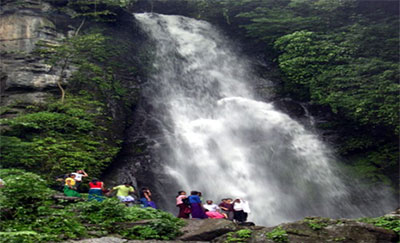 |
| Keibul Lamjao National Park | The only floating National Park in the world, on the Loktak Lake is the last natural habitat of the Sangai (Rucervus eldii eldii) the dancing deer of Manipur. It is situated at Moirang. A glimpse of the deer in this unique wetland ecosystem is a must for any wildlife enthusiast. Other wildlife to mention a few are: Hog deer, Otter and a host of water fowls and migratory birds can also be sighted during November to March. The forest Department of Manipur maintains watch towers and two rest houses within the park. | 50 kms | 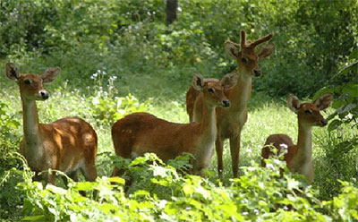 |
| Khongjom War Memorial | Khongjom War Memorial, 36 kms. from Imphal on the Indo-Myanmar road is a major historical place. It was here that Major General Paona Brajabashi, one of the great warriors of Manipur proved his valor against the superior might of the invading British Army in 1891. The hillock at the foot of which he laid down his life in defence of his motherland, is reminiscent of the past heroic deeds of Manipuri warriors. A war memorial has been constructed on the top of Kheba hill; and Khongjom day is celebrated every year on 23rd April. | 36 kms | 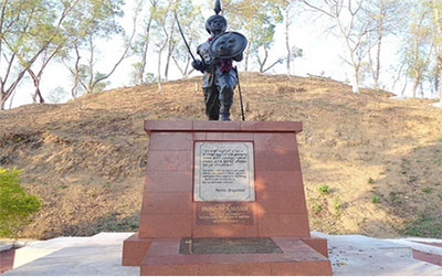 |
| Mutua Museum | This Museum, a Cultural Complex is at Andro village (about 26 kms.) from the capital. Here artifacts of the State and from all over the North East are housed, such as pottery collection,rare coins,rare manuscripts of the state, paintings, basketries, bell metals, jewelleries, wood carving etc. There are exact replicas of the houses from different tribes and groups of the state like: Poumai, Kabui, Meitei, Kuki, Tangk0hul etc. | – | 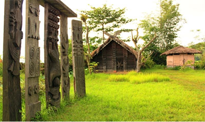 |
| Dzuko Valley | It is a very beautiful green valley and the mostpicturesque place in Senapati District bordering Nagaland. It is famous for its rare terrestrial lily called Dzuko Lily and the enchanting snow clad valley during January & February. The highest peak of Manipur Mount Iso is also located behind this valley. | – | 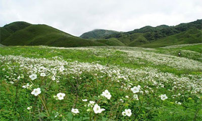 |
| Moreh Town | This is a busy market town on the Indo-Myanmar border, located at a distance of 110 kms. from Imphal. A commercial town and a real shopping paradise for shoppers where sundry products ranging from electronics to daily consumables are available in plenty. This place holds importance for the visiting tourists not only for being a border town but also for providing a unique opportunity to experience the different cultures, lifestyles of Myanmar through its border town at Tamu which is only 5 kms. away from here. There are ample hotels of medium range providing comfortable stay at Moreh. | 110 kms | 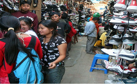 |
Parks/Gardens of Manipur
| Park/Garden Name | Brief Description | Opening Days, Time & Tickets | Distance from Imphal | Picture |
|---|---|---|---|---|
| Heaven Garden | Situated at: Tharoijam Village, Imphal (on the way to Yurembam) Suitable for: Kids, Family, Couples, Groups and Aged Persons Specialty: POSITIVE: Picturesque garden; open and airy, children playground; toys and trains; ample walking/jogging space, unique sculptures & handiworks; thatched-roof sitting arrangements, restaurants and food service, good road connectivity and ease of access. Also, OPEN on the following days of FESIVALS:- Yaoshang- Diwali- KangNEGATIVE: Average garden size, small or unspecified parking space, |
Days:Monday-Sunday Time:9 am – 6 pm Ticket:Adults – Rs 20, Kids (3 – 12 yrs) – Rs 10, Infants – N/A Parking Ticket:N/A Discounts on Advance Group Booking available for families, groups, picnic, et el. For discounts on Group Booking, contact Mr. xxxx on xxx. |
8 kms | 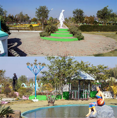 |
| Rose Garden | Situated at: , Imphal (on the way to Yurembam)Suitable for: Kids, Family, Couples & Groups – not recommended for Aged PersonsSpecialty: POSITIVE: Picturesque garden; variety of roses, children playground;; boat rowing; thatched-roof sitting arrangements, restaurants and food service, good road connectivity and ease of access. Also, OPEN on the following days of FESIVALS:- Yaoshang- Diwali- Kang NEGATIVE: No ample walking/jogging space, a bit stuffed up, no allotted parking space, frequented mostly by youngsters and couples |
Days:Monday-Sunday Time:9 am – 6 pm Ticket:Adults – Rs 20, Kids (3 – 12 yrs) – Rs 10, Infants – N/A Parking Ticket:N/A Discounts on Advance Group Booking available for families, groups, picnic, et el. For discounts on Group Booking, contact Mr. xxxx on xxx. |
8 kms | 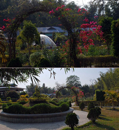 |
| Millennium Garden | Situated at:Haorang Saba, Imphal (on the way to Lamsang) Suitable for: Kids, Family, Groups and Couples – not recommended for Aged persons Specialty: POSITIVE: Picturesque garden; children playground; thatched-roof sitting & mats & carpets on hire arrangements, restaurants and food service, good parking space, good road connectivity and ease of access. Also, OPEN on the following days of FESIVALS:- Yaoshang- Diwali- Kang NEGATIVE: No ample walking/jogging space, frequented by youngsters and couples |
Days:Monday-Sunday Time:9 am – 6 pm Ticket:Adults – Rs 20, Kids (3 – 12 yrs) – Rs 10, Infants – N/A Parking Ticket:N/A Discounts on Advance Group Booking available for families, groups, picnic, et el. For discounts on Group Booking, contact Mr. xxxx on xxx. |
8 kms |  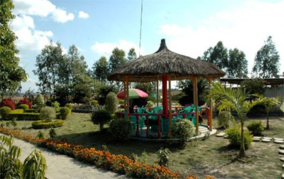 |
| Shangrilla Garden | Situated at: Imphal Suitable for: Kids, Family, Groups and Couples – not recommended for Aged persons Specialty: POSITIVE: Picturesque garden; trimmed grasses; thatched-roof sitting arrangements, restaurants and self-food service, good road connectivity and ease of access. Also, OPEN on the following days of FESIVALS:- Yaoshang- Diwali- Kang NEGATIVE: Average garden area, no ample walking/jogging space, frequented mostly by youngsters and couples |
Days:Monday-Sunday Time:9 am – 6 pm Ticket:Adults – Rs 20, Kids (3 – 12 yrs) – Rs 10, Infants – N/A Parking Ticket:N/A Discounts on Advance Group Booking available for families, groups, picnic, et el. For discounts on Group Booking, contact Mr. xxxx on xxx. |
8 kms | Not Available |
| Kombirei Garden | Situated at: Yaral Paat, Imphal (on the way to ) Suitable for: Groups and Couples – not for Kids, Family and Aged persons Specialty: POSITIVE: Picturesque garden; thatched-roof sitting arrangements, train-shaped restaurant and food service, good road connectivity and ease of access. Also, OPEN on the following days of FESIVALS:- Yaoshang- Diwali- Kang NEGATIVE: No allotted parking space, not enough space for walking/jogging, thatched-roof stuffed up, mostly frequented by youngsters and couples |
Days:Monday-SundayTime:9 am – 6 pm Entry Ticket:Adults – Rs 20, Kids (3 – 12 yrs) – Rs 10, Infants – N/A Parking Ticket:N/A Discounts on Advance Group Booking available for families, groups, picnic, et el. For discounts on Group Booking, contact Mr. xxxx on xxx. |
8 kms |   |
| Kakching Garden | Situated at: Uyok Ching, Kackhing (on the way to Moreh)Suitable for: Kids, Family, Group and Couples – not for Aged personsSpecialty:POSITIVE: Picturesque hill-top garden; 360 degree city view, unique sculptures; ample sitting arrangements and parking space, restaurants and food service, good road connectivity. No entry ticket. Also, OPEN on the following days of FESIVALS:- Yaoshang- Diwali- KangNEGATIVE: Steep hill slopes difficult for kids and aged persons, no proper direction-arrow boards, hill slopes difficult for weak vehicles | Days:Monday-Sunday Time:9 am – 5 pm Entry Ticket:Adults – N/A, Kids – N/A, Infants – N/A Parking Ticket:N/A Discounts on Advance Group Booking available for families, groups, picnic, et el. For discounts on Group Booking, contact Mr. xxxx on xxx. |
52 kms |  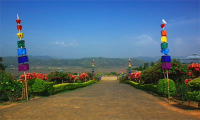 |
| Santhei Natural Park | Situated at: Andro, Imphal (E)Suitable for: Youngsters and Groups Specialty: POSITIVE: Mounted and spacious park bamboo-work seats; good parking space, nearby canteens and fast food outlets. No entry ticket. Also, OPEN on the following days of FESIVALS:- Yaoshang- Diwali- Kang NEGATIVE: Not so impressive landscape, difficult access road conditions, isolated, alcoholic drinks easily available, riskier in the evening hours, no proper sitting arrangements, not suitable for kids, family, couples and aged persons. |
Days:Monday-Sunday Time:9 am – 4 pm Entry Ticket:Adults – N/AKids – N/AInfants – N/A Parking Ticket:4 wheels – Rs 20, 2 wheels – Rs 10 Discounts on Advance Group Booking available for families, groups, picnic, et el. For discounts on Group Booking, contact Mr. xxxx on xxx. |
40 kms | 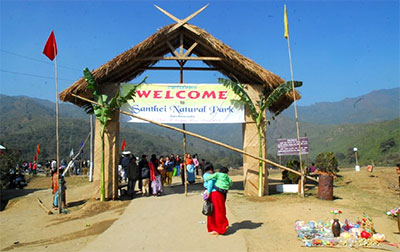 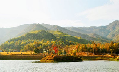 |
Major Festivals
| Festival Name | Celebration Month & Duration | Brief Description | Festival Picture |
|---|---|---|---|
| Eid-Ul-Adha The Feast of Sacrifice – celebrated by Manipuri Muslims |
Month: January Duration: 1 day |
EID-UL-ADHA, or the Feast of Sacrifice is also called yaum-un-Nahr, Qurban-i-Id, Qurban Bayram Baqr-i-Id (the Cow Festival) and the Great Feast, and is held in Manipur as elsewhere on the tenth day of the month Zul-Hijja.The sacrifice, as it is now performed on the ‘Id-ul-Azha’, is as follows:-The people assemble for prayer at the “Idgah as on the ‘Id-ul-Fitr’; after prayers the people return to their houses.The head of the family then takes a sheep (or a cow or camel) to the entrance of his house and sacrifices it, by repeating the words, “In the name of the great God,” and cutting its throat. The flesh of the animal is then divided, two-thirds being kept by the family, and one-third being given to the poor in the name of God. This feast is a great Muhammadan festival, which is observed wherever Islam exists and is celebrated in a calm and serene manner. | 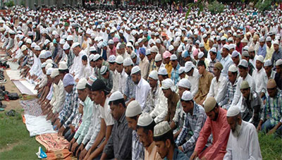 |
| Lui-Ngai-Ni The Seed Sowing Festival – Celebrated by Naga community |
Month: February Duration: 1 day |
The Nagas, consisting of almost 40 different tribes, have rich and colourful culture and Lui-Ngai-Ni is one of their many colourful festivals celebrated during the season of spring, signifying the sowing of seeds. It therefore is a collective festival of the Nagas observed on the 15th day of February every year.During this festival, the gods of crops are invoked to shower their blessings on the seeds sown so that they grow to bear fruits for bumper harvest in order that the general well-being of the people is ensured. The blessing of the Supreme Deity is besought with expressions through dances, songs, and rituals. And it is this cultural continuity that we see in some of the most delightful dances, songs and other customary rituals presented by Lui-Ngai-Ni every year.Lui-Ngai-Ni is a conglomeration of Tangkhul, Rongmei and Mao/Poumei dialect and is the modern form of the age old festival of spring. Social-gathering, songs, dances, foods and rejoicing highlight the festivity of Lui-Ngai-Ni and the festival plays a vital role in boosting the morale and strengthening the bond of Naga solidarity. | 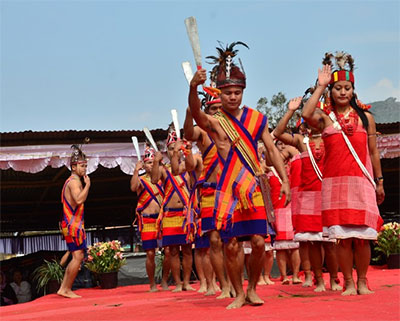 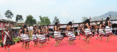 |
| Yaosang (Holi) The Festival of Colours & Thabal Chongba |
Month: February/March Duration: 5 days |
This Holi festival was known as “Loipan” festival by the traditional Meities at early times. It was the festival of the merriment of gods and goddesses of creation from the times immemorial circa 7000 B.C. In course of time the festival became synthesised with the Hindu festival of Holi during the reign of Jayshri Gharib-Niwaz Maharaja in 1709 and it became commonly known as Yaosang. The festival starts on the full-moon of Lamta Purnima- (February/March) and continues for five consecutive days. People wear new clothes and from the evening of the first of the festival itself until end of it, children in groups move around the locality from house to house begging money from door to door by saying NAKATHENGBA. Kids use colours and water guns for fun and enjoyment. In the night time the youngsters particularly girls of each and every locality supported by their local brothers organise their merry making Thabal Chongba (a folk dance in a circle).Apart from these, elderly people form Holipalas and move from house to house in a locality and sing Holi songs (prayers), youngsters move and roam around in bikes and cars and young girls stop plying vehicles asking for small sums either for fun or for Thabal Chongba contribution. On top of this, we can nowadays find in every locality big Sport Events organized by local clubs and this is becoming a major point of attention and attraction during this entire Yaoshang festival celebration gala. The festival usually ends with a small to big feast amongst family members, friends or colleagues. | 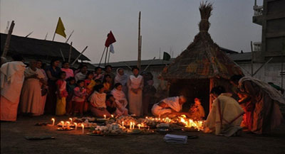  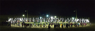 |
| Sajibu Cheiraoba Meitei New Year Day |
Month: March/April Duration: 1 day |
Sajibu Cheiraoba is an important traditional festival of the Meiteis held in every house on the first day of Sajibu month (March/April) every year.On this day, cleaning of the house, furniture and all kitchen utensils are done and the married ningols (women) do gifting of cloths to her parents, brothers and sisters and seek blessings from them.The women of every house arrange various items for offering prayers and prepare varied and a number of dishes for the family and the dishes are exchanged between neighbours and close relatives. Prayers are offered to Lainingthou Sanamahi and Leimarel Ima Sidabi and Emoinu (Meitei God and Goddesses) and other deities, praying for happiness and protection for the family.After the meal, most family members visit and climb the nearby Cheiraoching Hills and again seek blessings from the Gods abode the hills. Climbing of hills is traditionally regarded as a good start to the New Year, which may help bring and achieve great heights and success in everything one does in the rest of the year. Again, Thabal Chongba is organized at various places to enjoy as part of the festival. The festival carries an innate symbol of love, unity and faith among family members and the society. | 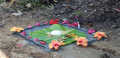 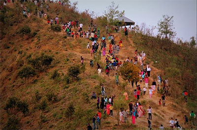 |
| Lai-Haraoba Festivity of the (Meitei) Gods |
Month: April-July Duration: Varies from place to place, ranging from 2-12 days. |
Lai-Haraoba is celebrated in honour of the sylvan deities known as Umang-Lais, meaning deities of calm and quite environment of beautiful forests. The festival represents the worship of traditional deities and ancestors of the Manipuri society. It is usually observed during the months of Kalen tha (summer season) and the duration of the festivals varies from place to place.Apart from various sacred arrangements and offerings, both rituals and dances, to the deities by Maiba-Maibis (Ojhas) , young and old alike offer various forms of dances and performances in front of the deities showing respect, dedication and love for their Gods and ancestors. The festival basically signify celebrating the creation and safe upbringing of the whole of universe and the human form by the God, and in respect and remembrance of this very fact, the festivity is performed and celebrated all over the state, especially by the Meitei community. The festival also is carried out in a very sacred and tactful manner as any negligence, ignorance or mistake from the part of the arrangers or participants may prove ominous. | 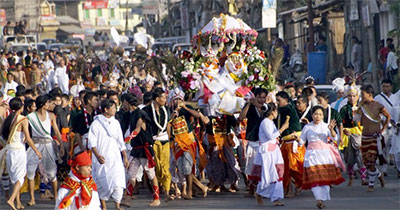 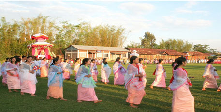 |
| Kang Rath Yatra of Manipur |
Month: June / July Duration: 10 days |
Although the festival is not originally from the state, it is celebrated all over the state in a big scale in our own traditional style. As it is observed in other parts of the country, especially in Orissa, the Rath (car) of Shri Jagannatha is drawn on the days of Rath Yatra (first day) and Puma Yatra (last day) from the celebration period of either eight, nine or ten days which ever may be as indicated by the astrologer from year to year. At every gate of the house people offer flowers, fruits and sweets to Shri Lord Jagannatha and His siblings wherever the Rath proceeds. In the evening, Jayadev-Chongba (a form of sankirtana) is performed at the Mandop of the temple wherever the Rath Yatra procession was conducted, followed by distribution of prasadam the “Kshechiri” (cooked rice with dal, turmeric, chilly and salt and ghee), Uthi (peas, pieces of bamboo shoot with salt and soda), “Ironba ” of “Laphu” (plaintain trunk) and some other items, and then served especially on the leaves of lotus. Everyone in the locality, men and women, young and old, can enjoy the servings and this act of goodwill and worship continues for another 8-10 days till the last day of Kang Chingba (Rath Yatra) festival. | 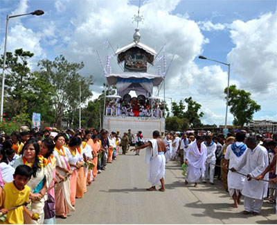 |
| Krishna Janmasthami Birthday of Lord Shri Krishna |
Month: August Duration: 1 day |
Like Yath Ratra, Shri Krishna Janmasthami has greatly been observed in Manipur valley by the Meitei Hindu community of Manipur since the installation of Shri Shri Govindajee by the Maharaja Bhagyachandra (Jai Singh Maharaja) during 18th Century. On this day, children, young and old, men and women go to the temples and offer whatever they can mainly fruits and flowers and pray to Lord Krishna (a complete incarnation of Lord Vishnu). After worshipping Sri Govindajee, people often go to the temple of Sri Hanumanjee, popularly known as Mahabali Thakur and offer worship to the Hanuman God by offering whatever one can and feed the monkeys resident in the forest of Mahabali Thakur. Small temporary stalls are usually erected in and around the temples of Shree Govindajee, Mahabali and ISKCON selling different kinds of toys, dolls, idols and many other handicrafts items made by local artisians. Food stalls especially set up for the day sell different items of eatables too. | 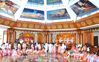 |
| Heigru Hidongba Royal Boat Race Festival |
Month: September Duration: 1 day |
This festival of Heigru Hidongba (Royal boat race) is only celebrated at a place in Imphal called Thangapat, located near Shree Bijoy Govindajee Temple at Sagolband.This festival or more of a ritual, which started during the reign of Meidingu Irengba around 984 and 1074 A.D, is basically the festival of the race of two boats which in essence is a prayer to God for the welfare of the people and the then country, especially performed by the king and the nobles under strict rules and rituals. The boat race however is commonly known to Manipuris as Hiyang Tannaba. The participants wear traditional Meitei (Manipuri) clothes and the festival usually takes place in the afternoon of the day, attracting large number of spectators. One unique thing associated with the festival is that eating Heigru (Amla or Gooseberry) in the Manipuri society is restricted until the performance of this very festival in the month of September. | 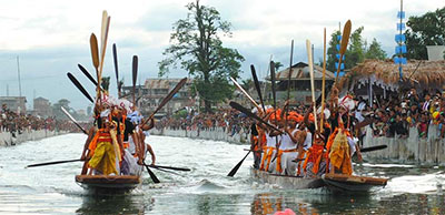 |
| Durga Puja Worshipping of Hindu Goddess Durga |
Month: October/ November Duration: 5 days |
Durga Puja festival, started circa 1714 during the reign of Meidingu Pamheiba (Gharib Niwaz Maharaja) following his conversion to Hinduism through the influence of a Shantidas Gosai, a Hindu Pandit who came from Sylhet, is observed for five consecutive days at most of the houses and at different places besides the main places of Sri Govindajee’s campus and Hiyangthang Lairembi Temple at the hill-lock of Hiyangthang, some 10 kms from Imphal. People do puja and worshipping of the Goddess Durga, the Goddess of Power, over these 5 days of celebration. Each day has a different significance and rituals are performed based on the significance of the event a particular day carries. The second day for example is observed as Boon Day when the Goddess grants and fulfills wishes of her devotees and worshippers and the last day as Kwak Tanba, signifying the victory of good over evil. People of all ages participate and enjoy the festival with full gaiety and children play with crackers and other fire toys adding more colour and joy to the festival. | 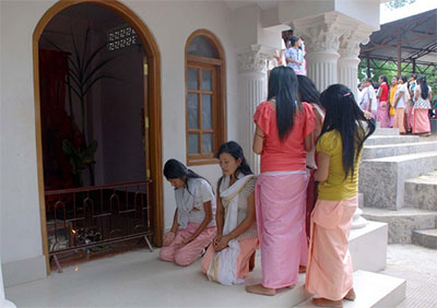 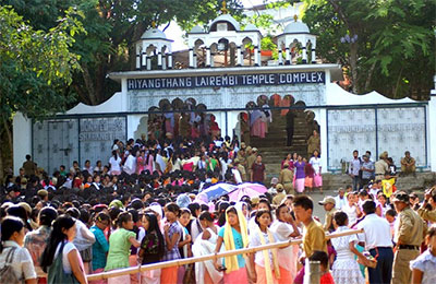 |
| Ningol Chak-Kouba Grand feast for married daughters at paternal house – arguably the biggest one of all Meitei festivals |
Month: October/November Duration: 1 day |
This festival falls on the second lunar day of Hiyangei (Oct/Nov) and is celebrated at each and every household of the Meitei community by arranging a grand feast especially for the married daughters of the family. On this day, the married daughters bring along with her fruits, eatables, clothes and other gifts for her parents, brothers and family members when she comes to her paternal house, while her brothers/parents arrange a grand feast to welcome her.After the grand meal, the parents and brothers present whatever gift they can make to the daughters/sisters who in turn bless her family members for happiness and prosperity for the whole year and for their future lives. This festival basically signifies the core love and respect between brothers and sisters of the family and develops brotherhood and purity of mind in the society as a whole. It is therefore regarded ominous for the individual or the family to do or think of doing anything bad to their sisters/daughters on this particular day. Even the worst of relationships and ill-feelings are forgotten, forgiven or forbidden on this auspicious day of Ningol Chak-kouba, thus ending up in the good arms of the family members with tears of repentance, forgiveness and happiness. Therefore, this festival not only has the meaning of its grand celebration but carries a great significance too which can change the mindset of an individual and the society as a whole towards their own and other’s family members and hence, can be regarded as the most significant and biggest of all festivals celebrated in the state of Manipur.As part of the celebration, there are musical shows and theatrical plays organized at various places and localities and people of all ages join together and enjoy the day wholeheartedly. Not only that, it can be seen that various social organizations invite daughters and sisters of other communities , thus creating a mutual love and understanding between various communities and tribes inhibiting the state.Such a festival is indeed a need of the hour as it has the innate power to bring peace, harmony, love and respect between individuals, family members and the society at large, |   |
| Diwali/Emoinu Iratpa The festival of lights/prosperity |
Month: November/January Duration: 1 day |
Goddess Lakshmi in Hindu and Emoinu Ema in Meitei society represent Goddess of wealth and prosperity. On the day of Diwali (mostly falls in November)/Emoinu Iratpa (falls in January), a chain of candle/artificial lights are decorated at each and every house of the Hindu/Meitei community in celebration of the festival, and as such this festival is usually referred to as festival of lights/prosperity. Women of every house do arrangements for the puja, and all family members get involved in the puja which usually gets underway in the evening time.And on the day of Emoinu Iratpa, at various places, the idols of Emoinu Ema are erected and worshipped. Traditional dance and other related shows are organized, especially in the evening hours, to mark and enjoy the spirit of the festival. Temporary shops and stalls at specific places like Ningthem Pukhrimapal (Imphal, near Palace Compound) sell idols of Emoinu Ema, handicrafts and kids toys, offering another form of attraction during the festival. Crackers and fire toys are becoming a common sight during the festival too. | 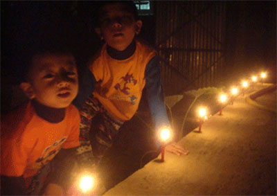 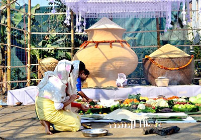 |
| Id-Ul-Fitr The feast of breaking the fast – celebrated by Manipuri Muslims |
Month: July-November Duration: 1 day |
Id-Ul-Fitr is also called the feast of Ramazan, the Feast of Alms or the Minor Festival. It is held on the first day of the month of Shawwal, which is the day after the close of the Ramazan fast, as such it is a feast of breaking the Ramazan fast.On this day, before going to the place of prayer, the Sadaqa or propitiatory offerings are made to the poor in the name of God. The offerings having been made, the people assemble either in the Jama-i-Masjid (i.e., the principal mosque) or proceed to the ‘Idgah’ which is a special place of worship on festivals.The worship commences with two rake at prayers, after which the Imam takes his place on the second step of the mimbar (pulpit) and recites the Khuthah, concluding with a prayer for the king.After this is ended, he offers up a munajat or supplication, for the people, for the remission of sins, the recovery of the sick, increase of rain, abundance of corn, preservation from misfortune, and freedom from debt. He then descends to the ground, and makes further supplication for the people, the congregation saying Amirz at the end of each supplication.At the close of the service the members of the congregation salute and embrace each other, and offer mutual congratulations and then return to their homes, and spend the rest of the day in feasting and merriment | 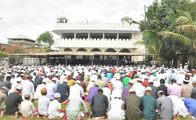 |
| Chavang Kut Festival Harvesting Festival of Kuki-Chin-Mizo tribes |
Month: November Duration: 1 day |
Kut is an autumn festival and is the greatest and the most joyful Festival celebrated by the Kuki-Chin-Mizo tribes in Manipur. The festival has also been variously described as Chavang-Kut or Khodou at different places amongst different tribes. It is a happy occasion for the villagers to celebrate their food stock after a year of hard labor. The festival is celebrated with a thanksgiving feast paired with songs and dances in honor of the giver of an abundant harvest. The people of the Kuki-Chin-Mizo community offer their thanks to the Lord for bestowing upon them a good harvest during the Kut festival.This festival is observed on the 1st of November every year. During this time of the year, the whole harvested crop is gathered and the farmer jubilantly celebrates this in the accomplishment of his hard work throughout the year. Tourists and local visitors can get to know of the culture and can also savor the exotic tribal dishes during the Kut fiesta. The Kut festival is marked by merriment; food and fun during the Kut fest.The festival in Kut is accompanied by traditional folk song and dance and the native tribes of Manipur indulge in merry making. The folk dance and music are performed to celebrate the special festive occasion of Kut. The festival in Kut relieves the people from the stress and strains of daily agriculture life. The festival also marks the use of traditional folk instruments. The folk dance and music reflects the unique cultural pattern and lifestyle of the tribes. The local tribes of Manipur clean and whitewash their houses to welcome the festival in their community.In modern times, Miss Kut, a beauty cum entertainment show organized by the community is a popular part of the Kut festival and is attended by many government officials and well-to-do families, apart from the general audience. | 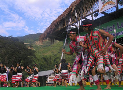  |
| Gaan-Ngai Post Harvest/Winter Festival – celebrated by Zeliangrong community |
Month: December/ January Duration: 5-7 days |
Gaan-Ngai is the greatest festival of the Zeliangrong (a combined name of three cognate kin group namely Zeme, Liangmai and Rongmei) who inhabit in the State of Manipur, Assam and Nagaland. Gaan-Ngai literally means the festival of winter season and is a post harvest festival. When the granaries are full, the landscape is dry, the whole village is free from all agricultural works, people turn to celebration, festivity and worship of the God and honouring of the dead. This festival is also described as a new year festival as it marks the end of the year and beginning of a new year. Those who died in the previous year are given ritual farewell or departure; their graves are beautified, dances are performed in their honour, feast is given to the community in the honour of the dead during the Gaan-Ngai festival. It therefore is the festival of both the death and the living. The festival is continuously celebrated for five to seven days depending on local variations. Thus the Gaan-Ngai comes to an end. At the end of the festival, the community prays to Tingkao Ragwang as a Thanksgiving and for future prosperity (good harvest), the soul of the death leaves the households and go to the land of the death (Taroilam), the village reinvigorates its energy by affirmation of strength and unity, rejoices in the performance of dance, music, merry making and festivities. Gaan-Ngai is the essence of the Zeliangrong culture through which the community sustains their cultural heritage and way of life. | 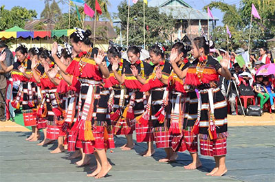 |
| Christmas Celebrated by Manipuri Christians |
Month: December Duration: 1 day |
Christmas is celebrated with full devotion and enthusiasm by the Christians of the state on the 25th December every year as is celebrated in all Christian countries. As everyone knows, it is celebrated to mark the auspicious birth of Jesus Christ who showed the path of truth and heaven to the mankind. Every house is decorated and all members of the family go to Church and offer prayers, sing hymns in praise of God and people in group go caroling both on the Christmas eve and on the Christmas day. Singing as an expression of joy, hope, love and any other good human feelings has been part of the Christmas celebration everywhere. Streets and houses are well lighted and the sounds of church bells make the atmosphere more serene, pure and festive on this day. In addition to prayers, singing and decoration, Christmas season is marked by tasty things to eat. This is the time when every Christian family rejoices at its best, offers the best of prayers and prays for the poor and needy for their safety and prosperity. Christmas anywhere is a simple story, divinely simple, yet profoundly inspiring showing what life may mean for each of us. Christ came into this world on this Day but we cannot more explain His birth than we can explain the origins of sun, the moon and the stars. | 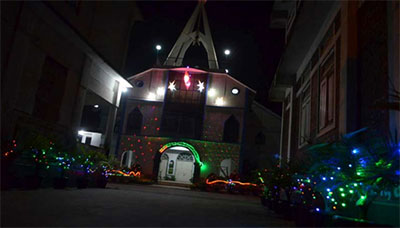 |
Important & Emergency Contacts
NOTE: Prefix Country Code “+91” and/or STD code “0385” as appropriate for all Landline Numbers before dialing.
The phone numbers are recorded from various sources and the authenticity or validity of the numbers provided hereinunder are therefore not guaranteed to be always functional/operational as the numbers may either go invalid or unoperational in course of time due to several reasons out of our control. help-yourself.in should not therefore be held liable for any discrepancies or untoward incidents resulting out of such non-functionality or inaccurateness of the data thus presented.
| Services | Department / Entity Name | Emergency Type | Sub-Dep / Sub-Entity/ Place Name |
Phone 1 | Phone 2 | Phone 3 | Phone 4 |
|---|---|---|---|---|---|---|---|
| HOSPITALS & AMBULANCE | RIMS | Casualty & Ambulance | Lamphel – Imphal (W) | 2414728 | 2414728 | 2414478 | 2414434 |
| Shija Hospitals & Research Institute | Hospital Emergency | Lamphel – Imphal (W) | 2413163 | ||||
| Imphal Hospitals & Research Centres | Hospital Emergency | Lamphel – Imphal (W) | 2410333 | 2411353 | |||
| JNIMS | Hospital Casualty | Porompat – Imphal (E) | 2220129 | 2422218 | 2220385 | 2223516 | |
| Clinic Maroodyar Research Centre | Hospital Emergency | Palace Gate – Imphal (W) | 9206192545 | ||||
| Mrityunjoy -108 | Ambulance Service | N/A | 108 (toll free) | ||||
| MANIPUR POLICE | Director General of Police (DGP), Manipur | Law & Order | Imphal (W) | 2450289 | 2246461 | ||
| Police Control Room | Law & Order | N/A | 100 (toll free) | 2440100 | |||
| O.C. Imphal Police | Law & Order | Imphal (W) | 2220002 | 2220320 | |||
| O.C. Patsoi Police | Law & Order | Patsoi | 2436015 | 2436015 | |||
| O.C. Lamphel Police Station | Law & Order | Lamphel | 2414616 | ||||
| OC (City Control) | Law & Order | Imphal (W) | 2228515 | ||||
| SP (Control Room | Law & Order | Imphal (W) | 2220214 | ||||
| MANIPUR FIRE SERVICES | Fire Control room | Fire Control | Imphal | 101 (toll free) | 2220101 | ||
| Director, Fire Service | Fire Control | Imphal | 2451539 | ||||
| Fire Stations | Fire Control | Bishnupur | 259 | ||||
| Imphal | 101 | 223109 | |||||
| Mayang Imphal | 233 | ||||||
| Moreh | 303 | ||||||
| Thoubal | 22306 | ||||||
| Kakching | 252 | ||||||
| Churachandpur | 2210 | ||||||
| Jiribam | 204 | ||||||
| Kangpokpi | 270 | ||||||
| Moirang | 229 | ||||||
| Tamenglong | 220 | ||||||
| RELIEF & DISASTER MANAGEMENT | Flood Control & Drainage | Water Disaster | Imphal | 2220204 | 2414261 | 2228389 | |
| MANIPUR ELECTRICITY SERVICES | Electricity Services | Electricity Complaints | Keishampat | 2220169 | |||
| Singjamei | 2220983 | ||||||
| Lamphel | 2310730 | ||||||
| Lamlong | 2221568 | ||||||
| Chief Engineer (Power) – Imphal | 2220050 | ||||||
| AIRPORT SERVICES | Airport | Travel & Safety | Imphal | 2220888 | |||
| Airport (City Office) | Travel & Safety | Imphal | 2220999 | ||||
| MANIPUR TELECOM SERVICES | Telecommunications | Telephone Directory Section | Imphal | 2227812 | |||
| Telephone Complaint | Sawombung | 267299 | |||||
| Telephone Complaint | Lamphel Exchange | 2414222 | |||||
| Telephone Bhawan | Imphal | 2444196 | 2230777 | ||||
| Enquiry | BSNL | 197 | |||||
| Fault Repairing | BSNL | 198 | |||||
| Trunk Booking | BSNL | 180 | 181 | ||||
| MANIPUR POSTAL SERVICES | Postal Services | Director Postal Services | Imphal (W) | 2450264 | 2228759 | 2222239 | 2222236 |
| Speed Post Enquiry | Imphal (W) | 220146 |
